

Field guides / Gilgit Division / Hunza / Khunjerab Pass
Field guide · Nature
Gilgit Division
Hunza District · Gilgit-Baltistan, Pakistan
Khunjerab Pass
High Karakoram border landscape with major wildlife and mountain-route significance.
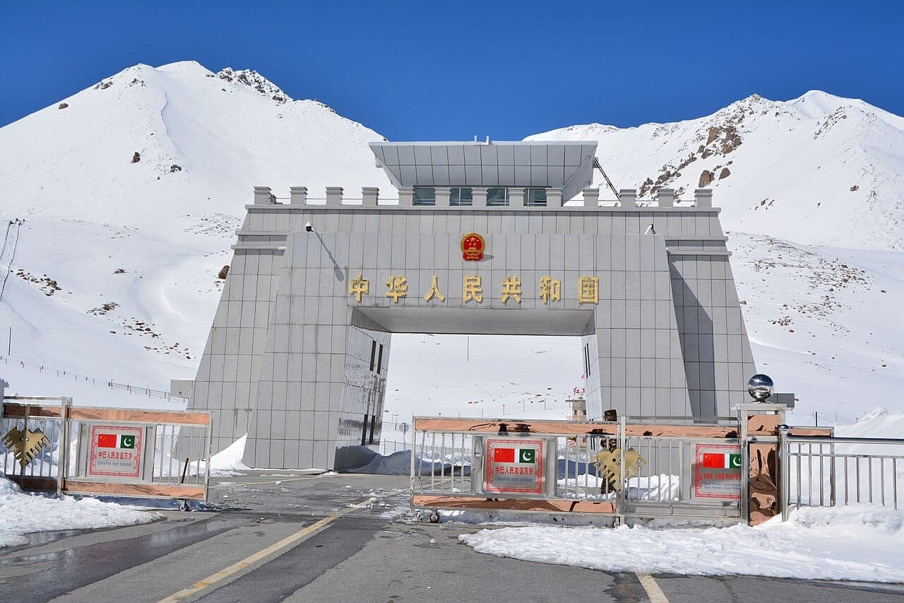
The Khunjerab Pass is the highest paved international border crossing in the world, 4,693 m on the crest of the Karakoram, where the Karakoram Highway leaves Pakistan and enters China's Xinjiang. The name means 'Valley of Blood' in Wakhi, a reference to old bandit raids on the caravans that once crossed here, but today the pass is a place of pilgrimage for road-trippers: a stark, wind-scoured saddle marked by border gates, a stone arch, and grazing yaks, with the Pamir and Karakoram rolling away on both sides. It lies within Khunjerab National Park, prime habitat for Marco Polo sheep, snow leopard, ibex, and blue sheep.
Why go
- ✦Highest paved border crossing on Earth (4,693 m)
- ✦The Karakoram Highway, the 'Eighth Wonder of the World'
- ✦Khunjerab National Park wildlife
- ✦Pakistan-China border gate and arch
- ✦Yaks and high-Pamir scenery
The Top of the Karakoram Highway
Reaching Khunjerab is the natural climax of any KKH journey. The highway, a joint Pakistan-China feat of engineering blasted through the world's youngest and most unstable mountains over two decades, climbs steadily up the Gojal valley past Passu and Sost to the pass. At the top, a simple gate and arch mark the frontier, with Pakistani and Chinese posts facing each other across the watershed. It is bleak, cold, thin-aired, and unforgettable.
Altitude and Acclimatisation
The jump from Hunza (around 2,400 m) to Khunjerab (4,693 m) in a single drive is significant, and altitude sickness is common at the top, headaches, breathlessness, and nausea. Spend a couple of nights in Hunza or Passu first, go up slowly, stay hydrated, limit your time at the summit, and descend if symptoms worsen. The pass is a stop, not a place to linger long.
Khunjerab National Park
The pass sits inside one of Pakistan's most important high-altitude reserves, created in part to protect the Marco Polo sheep with their enormous spiralling horns. Snow leopard, Himalayan ibex, blue sheep, and golden marmots also live here, and the lower slopes are grazed by yaks. Wildlife is shy and the terrain vast, so sightings are a bonus rather than a guarantee, but the sense of being in genuinely wild, protected high country is constant.
Planning tip
Best Time to Visit, May to October, when the pass is open and the road clear of snow. The border itself keeps seasonal hours and closes through winter.
Getting there, The northern terminus of the Karakoram Highway, about 4 hours' drive from central Hunza via Sost. Most travellers visit as a day trip from Hunza or Passu, the altitude gain from the valley is large, so acclimatise before going up.
Allow, A full day from Hunza for the drive up and back; longer if combining with Sost and the upper Gojal valley.
What to Do
Make Khunjerab Pass Part of a Trip
GreenPak resorts and journeys within 5 km of Khunjerab Pass.
Nearby
Straight-line distance from Khunjerab Pass, within 5 km.
Nothing else genuinely close by (within 5 km of Khunjerab Pass) is published yet.