 Photo: GB Tourism
Field guides / Diamer Division / Fairy Meadows & Nanga Parbat / Allah Wali Jheel
Field guide · Nature
Diamer Division
Astore District · Gilgit-Baltistan, Pakistan
Allah Wali Jheel
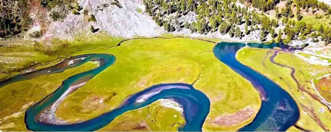
A river bend at the end of Parishing valley, near Astore, whose loops form the word “Allah” when seen from above.
Allah Wali Jheel is at the far end of the Parishing valley near Gotamsar, about 45 minutes' drive from Astore. It is one of the oldest and best-known spots in the Astore valley.
Why go
- ✦River loops that form the word “Allah”
- ✦Green fields under high mountains
- ✦45 minutes from Astore
- ✦One of Astore's oldest tourist spots
About
The name comes from the shape of the river: winding in zigzags through green fields, it forms the Arabic word for Allah, clearly visible from higher ground. The open fields around it, under high mountains, are used for games and picnics.
How to Reach
About 45 minutes' drive from Astore, at the end of the Parishing valley near Gotamsar.
Responsible Travel
Use Leave No Trace principles, carry out all rubbish, avoid disturbing wildlife and livestock, and respect private/community land.
Planning tip
Best Time to Visit, June to September.
Getting there, About 45 minutes' drive from Astore, at the end of the Parishing valley near Gotamsar.
Allow, Half a day from Astore.
What to Do
Nearby
Straight-line distance from Allah Wali Jheel, within 5 km.
Nothing else genuinely close by (within 5 km of Allah Wali Jheel) is published yet.