

Road trip routes / Gilgit-Baltistan
Karakoram Highway: Jaglot to Khunjerab
16.7h
Drive time
521 km
Distance
Opens turn-by-turn directions in your Maps app. This is a planning route, not a live booking or road-condition guarantee.
Route Details
Times assume a 7:00 AM start — a planning estimate, not a schedule.
7:00 AM
Raikot Bridge (Nanga Parbat View Point) (Start)
The roadside viewpoint for Nanga Parbat (8,126 m) and the turnoff for the jeep track and trek to Fairy Meadows and Nanga Parbat Base Camp, a short distance before Jaglot.
7:34 AM
Jaglot
The junction of three of the world's mightiest mountain ranges, the Himalayas, Karakoram, and Hindu Kush, and the confluence of the Gilgit and Indus rivers, marked by a roadside signboard.
29 km · 0.6 h from Raikot Bridge (Nanga Parbat View Point)
8:25 AM
Sal Nala
A quiet picnic spot just off the highway with fresh water and mountain views.
15 km · 0.9 h from Jaglot
9:52 AM
Gilgit
The regional capital, at the confluence of the Gilgit and Hunza valleys, a natural stop for fuel, rest, and supplies.
51 km · 1.5 h from Sal Nala
12:10 PM
Naltar Valley
A worthwhile side-valley detour near Nomal, about 26 km from Gilgit, for its lakes and ski resort, reached via its own spur road off the highway.
50 km · 2.3 h from Gilgit
2:29 PM
Rakaposhi View Point (Ghulmet)
The best roadside mountain view on the entire KKH, in Ghulmet village, Nagar, with the closest highway view of the 7,788 m Rakaposhi.
62 km · 2.3 h from Naltar Valley
3:56 PM
Hopar Glacier, Nagar
A short side-valley detour to the Bualtar Glacier, reachable on foot from the last village.
48 km · 1.5 h from Rakaposhi View Point (Ghulmet)
5:12 PM
Karimabad
The central town of Hunza, terraced beneath Baltit Fort and the natural base for the whole valley.
24 km · 1.3 h from Hopar Glacier, Nagar
5:23 PM
Baltit Fort
The roughly 700-year-old former seat of Hunza's rulers, above Karimabad.
2 km · 0.2 h from Karimabad
5:33 PM
Altit Fort
Hunza's oldest monument, a watchtower over the river gorge below Karimabad.
5 km · 0.2 h from Baltit Fort
5:50 PM
Ladyfinger Peak
The slender granite spire that is Hunza's most recognisable skyline, visible from Karimabad.
6 km · 0.3 h from Altit Fort
—
Ganish Village
The oldest Silk Road settlement in Hunza, at least 1,000 years old, with a UNESCO heritage award.
6:04 PM
Sacred Rocks of Hunza (Haldeikish)
Thousands of Silk Route petroglyphs and inscriptions on a hillside between Ganish and Attabad.
4 km · 0.2 h from Ganish Village
6:47 PM
Attabad Lake
The turquoise lake formed by the 2010 landslide, one of Hunza's best-known sights.
31 km · 0.7 h from Sacred Rocks of Hunza (Haldeikish)
7:09 PM
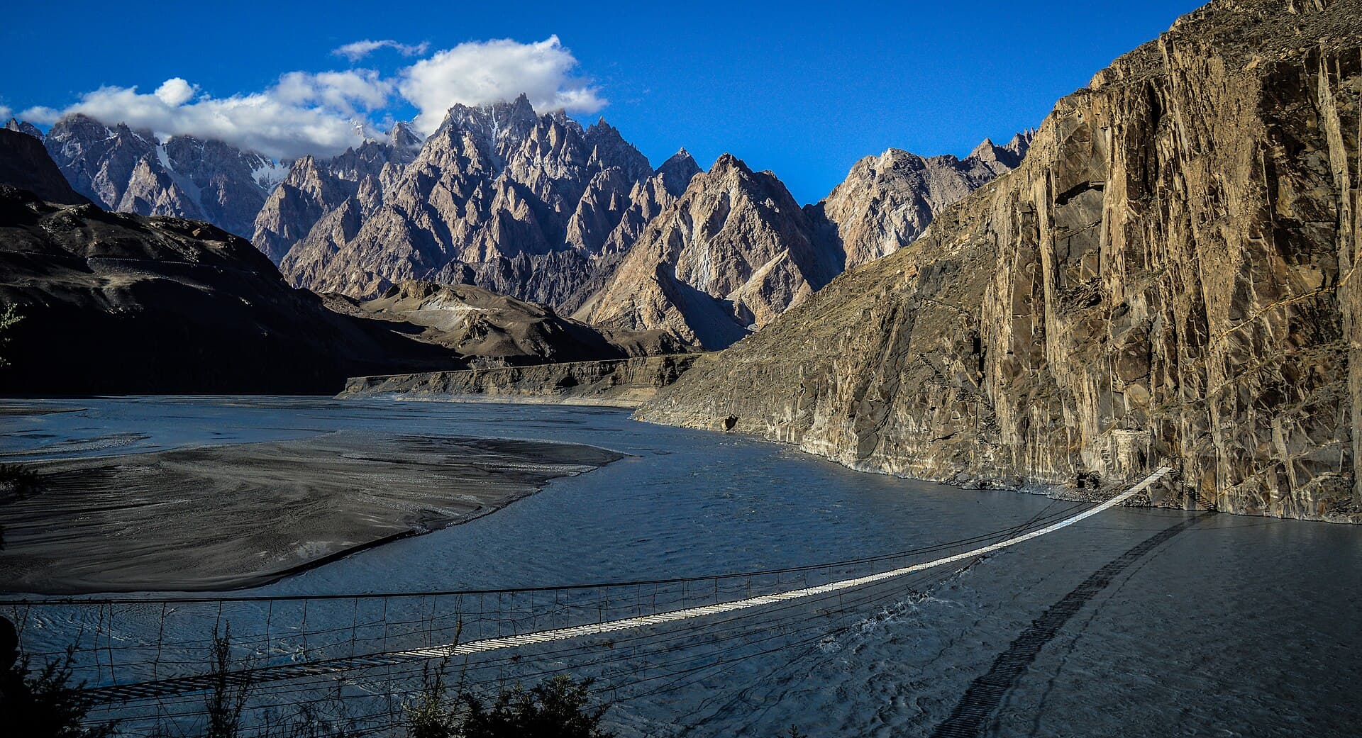
Hussaini Suspension Bridge
A 194-metre rope-and-plank footbridge over the Hunza River, with the Passu Cones behind it.
11 km · 0.4 h from Attabad Lake
7:26 PM
Passu Cones
The jagged Passu Cathedral peaks, one of the most photographed skylines on the KKH.
12 km · 0.3 h from Hussaini Suspension Bridge
—
Passu Glacier
Visible directly from the highway near Passu village.
7:34 PM
Batura Glacier
One of the longest glaciers outside the polar regions, near Passu.
4 km · 0.1 h from Passu Glacier
8:12 PM
Sost
The last town before Khunjerab, with the dry port and immigration checkpoint.
22 km · 0.6 h from Batura Glacier
11:39 PM
Khunjerab Pass / National Park (End)
The highest paved international border crossing in the world at 4,693 m, and a wildlife sanctuary for Marco Polo sheep and snow leopards.
145 km · 3.5 h from Sost
Photo: Mehtab Alam · CC BY-SA 4.0Road Trip Routes / Karakoram Highway: Jaglot to Khunjerab
Karakoram Highway: Jaglot to Khunjerab
The classic Karakoram Highway corridor from the junction of three mountain ranges at Jaglot, through Gilgit and the whole of Hunza, to the highest paved border crossing on Earth at Khunjerab Pass.
Distance
521 km
Drive time
16.7 h
Best time to go
May to October; Khunjerab Pass closes with winter snow.
Road conditions
Fully paved and in good condition the entire way; landslide-related delays are occasional near Attabad and in Gojal after heavy rain.
Route Overview
The classic Karakoram Highway corridor from the junction of three mountain ranges at Jaglot, through Gilgit and the whole of Hunza, to the highest paved border crossing on Earth at Khunjerab Pass.
Stop by Stop
In driving order. Significant stops link to their own field guide; the rest are labelled waypoints along the way.
Raikot Bridge (Nanga Parbat View Point)
The roadside viewpoint for Nanga Parbat (8,126 m) and the turnoff for the jeep track and trek to Fairy Meadows and Nanga Parbat Base Camp, a short distance before Jaglot.
Jaglot
The junction of three of the world's mightiest mountain ranges, the Himalayas, Karakoram, and Hindu Kush, and the confluence of the Gilgit and Indus rivers, marked by a roadside signboard.
29 km · 0.6 h from the previous stop
Sal Nala
A quiet picnic spot just off the highway with fresh water and mountain views.
15 km · 0.9 h from the previous stop
Gilgit
The regional capital, at the confluence of the Gilgit and Hunza valleys, a natural stop for fuel, rest, and supplies.
51 km · 1.5 h from the previous stop
Naltar Valley
A worthwhile side-valley detour near Nomal, about 26 km from Gilgit, for its lakes and ski resort, reached via its own spur road off the highway.
50 km · 2.3 h from the previous stop
Rakaposhi View Point (Ghulmet)
The best roadside mountain view on the entire KKH, in Ghulmet village, Nagar, with the closest highway view of the 7,788 m Rakaposhi.
62 km · 2.3 h from the previous stop
Hopar Glacier, Nagar
A short side-valley detour to the Bualtar Glacier, reachable on foot from the last village.
48 km · 1.5 h from the previous stop
Karimabad
The central town of Hunza, terraced beneath Baltit Fort and the natural base for the whole valley.
24 km · 1.3 h from the previous stop
Baltit Fort
The roughly 700-year-old former seat of Hunza's rulers, above Karimabad.
2 km · 0.2 h from the previous stop
Altit Fort
Hunza's oldest monument, a watchtower over the river gorge below Karimabad.
5 km · 0.2 h from the previous stop
Ladyfinger Peak
The slender granite spire that is Hunza's most recognisable skyline, visible from Karimabad.
6 km · 0.3 h from the previous stop
Ganish Village
The oldest Silk Road settlement in Hunza, at least 1,000 years old, with a UNESCO heritage award.
Sacred Rocks of Hunza (Haldeikish)
Thousands of Silk Route petroglyphs and inscriptions on a hillside between Ganish and Attabad.
4 km · 0.2 h from the previous stop
Attabad Lake
The turquoise lake formed by the 2010 landslide, one of Hunza's best-known sights.
31 km · 0.7 h from the previous stop
Hussaini Suspension Bridge
A 194-metre rope-and-plank footbridge over the Hunza River, with the Passu Cones behind it.
11 km · 0.4 h from the previous stop
Passu Cones
The jagged Passu Cathedral peaks, one of the most photographed skylines on the KKH.
12 km · 0.3 h from the previous stop
Passu Glacier
Visible directly from the highway near Passu village.
Batura Glacier
One of the longest glaciers outside the polar regions, near Passu.
4 km · 0.1 h from the previous stop
Sost
The last town before Khunjerab, with the dry port and immigration checkpoint.
22 km · 0.6 h from the previous stop
Khunjerab Pass / National Park
The highest paved international border crossing in the world at 4,693 m, and a wildlife sanctuary for Marco Polo sheep and snow leopards.
145 km · 3.5 h from the previous stop